


/cdn.vox-cdn.com/uploads/chorus_asset/file/25518688/8A0A1493.jpeg)


AllTrails review: an essential app for hobbyist hikers and walkers
AllTrails is perhaps the best-known hiking app out there. We bring it up mountains, across rivers, and through woodlands to test its mettle.
AllTrails: Two minute review
AllTrails is a hiking app that allows you to search for local hikes and trails, plan your routes ahead of time, and follow your progress along the route to ensure you don’t get lost. You can also rate the trail for other users, upload photos, follow other hikers and keep a virtual diary of your trail experiences.
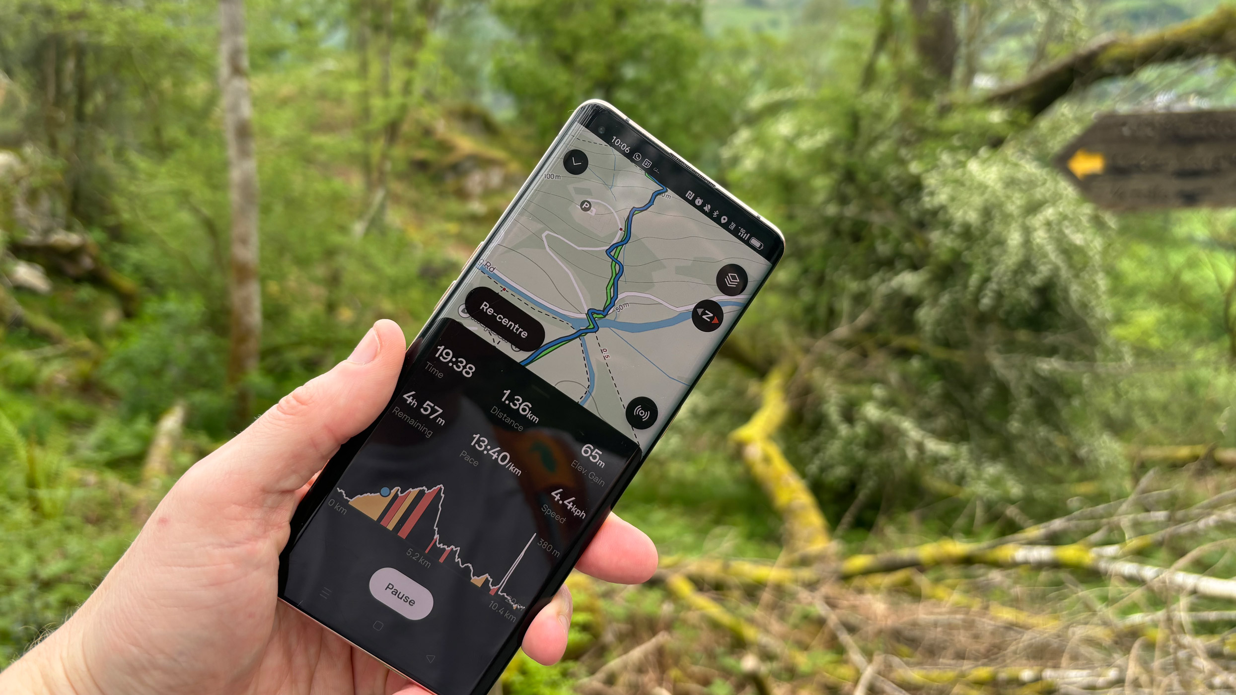
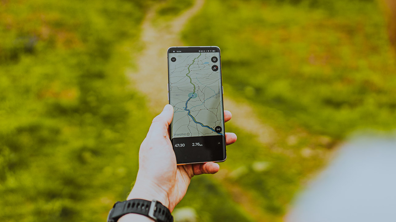
It was named Apple’s “iPhone app of the year” in 2023 – and for good reason: it’s a great community app, and one of the best fitness apps around, especially for hikers and nature lovers. It’s essentially Strava for hikers, rather than runners and cyclists, and the two share many similar features. These include showing your followers GPS maps of the trails you’ve walked; the ability to upload and share media; estimated stats such as calorie counts; and more accurate GPS-generated information such as distance, elevation and moving time.
It’s missing some of Strava’s reliance on competition with aspects such as segments, but that isn’t necessarily a bad thing. Hiking isn’t trail-running or particularly competitive, and an AllTrails representative told me this was a deliberate choice. Features such as segments and leaderboards are unlikely to arrive on this particular community-based app. Competition can breed elitism, and AllTrails is designed to democratize hiking.
In this, the app certainly succeeds. The average person who’s never hiked before can filter by length, difficulty or style of walk (such as “nearby”, “circular” or “pub walk”), pick a trail, read the reviews, and follow a GPS map all the way round. I’ve used the free version on For AllTrails+ members, where helpful haptic feedback hints alert the user when they stray too far from the trail, reducing the chance of the user even taking a wrong turn.
Once the user has completed their walk, they can share their media, review by stars and add comments (such as “very muddy in winter, bring walking boots”). AllTrails then takes all this community information and uses it in its calculations to serve others the same trail. It’s a simple concept, and one that’s very well-executed; it’s well worth a free download for even the most occasional hiker.
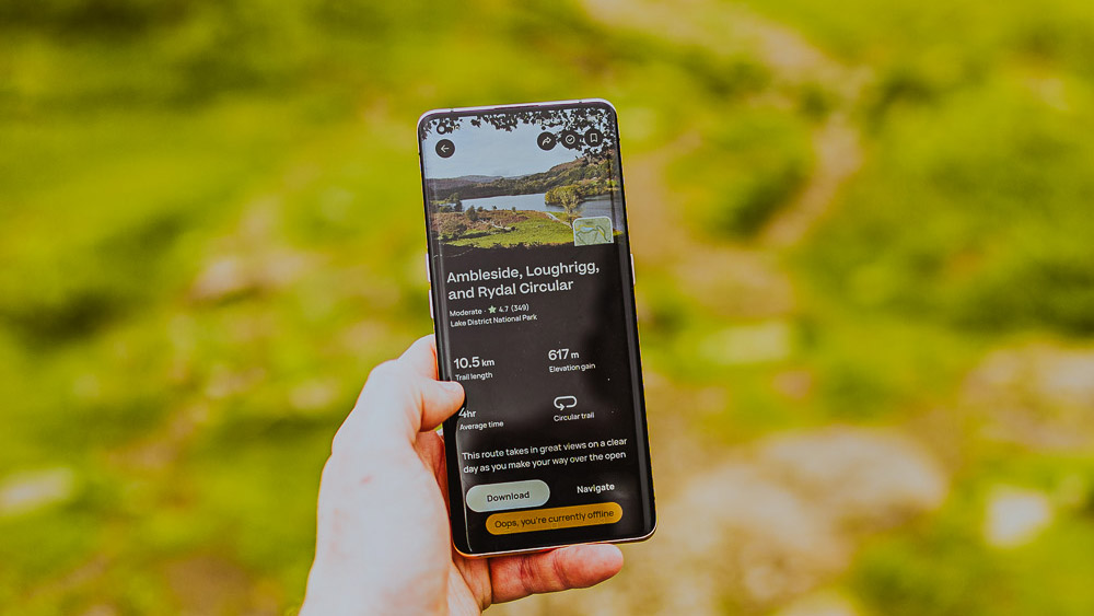
Regular walkers and serious multi-day hikers will get more out of AllTrails+, which is competitively priced at $34.99 / £35.99 / AU$35.99. For the extras, you get more sophisticated filtering of local trails, those wrong-turn alerts, the option of 3D maps, the ability to download trails and save them for offline use (indispensable on more remote walks), and a Live Share tool. Live Share works like the LiveTrack feature on the best Garmin watches, broadcasting your location to anyone with the Live Share URL in case something goes wrong on the trail.
There’s very little to dislike about AllTrails: it’s a great community tool; the Plus version is reasonably priced, and every trail is vetted by a human before being shared with the community. Unfortunately, being largely user-driven, I did find some complaints online. These were mainly about the fact that the trails can be outdated or feature incomplete information, such as taking you across land that has been privatized.
I experienced one such issue during testing in the Lake District, with a small part of an AllTrails route attempting to lead me across a short stretch of private land. As previously mentioned, it’s worth checking the reviews and route before you go to see if the community has picked up on anything.
Smartwatch integration is a little underwhelming: maps are only shared to the watchOS or Wear OS via the premium version; otherwise, it’s a simple start/stop button and a few basic metrics. Another hiccup is that when using the free version, navigation is dependent on cell service, so more remote hikes require the premium version to follow the map as you go.
AllTrails: Specifications
AllTrails: Scorecard
AllTrails: Should I buy?
Buy if it...
Don't buy it if...
Also consider
How I tested
I used the free version of AllTrails on several hikes around the UK – in Wales, Cornwall and the Chilterns – and tested AllTrails+ on three hikes in the UK’s Lake District National Park. I examined the different kinds of filters on offer for searching out new hikes, tried both 3D and 2D map data on each of the AllTrails+ hikes I went on, and tested the map route and GPS accuracy against data from my Garmin Epix Pro.
What's Your Reaction?